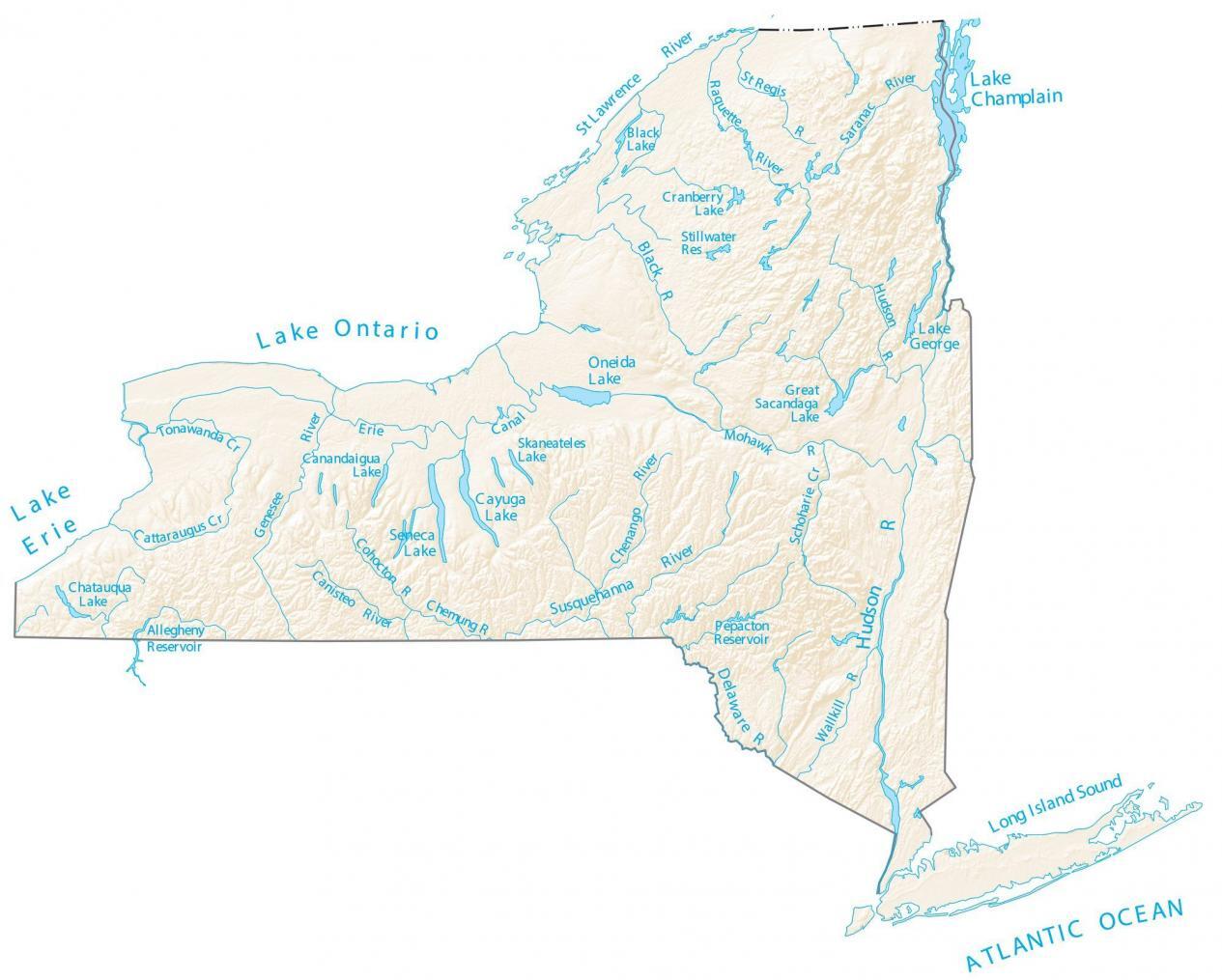
New York is a state that is rich in waterways. It is home to numerous rivers, streams, lakes, and other bodies of water that form an important part of the state’s geography and ecosystem. These waterways not only provide recreational opportunities but also support the state’s economy through shipping, tourism, and other industries. In this essay, we will take a closer look at the New York Rivers Map and the significance of each river in the state.
New York Rivers Map

Click Here to Download
The Hudson River is one of the most prominent and well-known rivers in New York. It originates in the Adirondack Mountains and flows for over 300 miles through the state before emptying into the Atlantic Ocean. The river is an important part of New York’s history, as it was a major thoroughfare for commerce and transportation in the state’s early days. Today, the Hudson River is a popular destination for boating, fishing, and other recreational activities. It is also home to several important wildlife habitats, including the Hudson River Estuary, which is a critical breeding ground for numerous species of fish and birds.
The Mohawk River is a major tributary of the Hudson River, flowing for over 130 miles through central New York. It has played a significant role in the state’s history, as it was a major transportation route for goods and people in the early days of European settlement. The river is also a major source of drinking water for the cities and towns that are located along its banks. Today, the Mohawk River is used for a variety of recreational activities, including boating, fishing, and kayaking.
The Susquehanna River is another major river in New York that is important to the state’s economy and ecosystem. It originates in the hills of central New York and flows for over 400 miles through the state before emptying into the Chesapeake Bay. The river is an important source of drinking water for the communities located along its banks and is also used for irrigation, hydroelectric power generation, and other purposes. The Susquehanna River is also a popular destination for fishing, boating, and other recreational activities.
The St. Lawrence River is a major waterway that forms the boundary between the United States and Canada. It originates in the Great Lakes and flows for over 1000 miles through the northeastern United States and Canada before emptying into the Atlantic Ocean. The river is an important shipping route for goods and raw materials, and it also provides critical habitat for numerous species of fish and other wildlife. In addition, the St. Lawrence River is a popular destination for boating, fishing, and other recreational activities.
The Genesee River is a major river in western New York that originates in the hills of the Finger Lakes region and flows for over 100 miles before emptying into Lake Ontario. The river is an important source of drinking water for the communities located along its banks and is also used for hydroelectric power generation, irrigation, and other purposes. The Genesee River is also a popular destination for fishing, boating, and other recreational activities.
The Delaware River is a major river that forms the boundary between New York and Pennsylvania. It originates in the Catskill Mountains and flows for over 300 miles through the two states before emptying into the Atlantic Ocean. The river is an important source of drinking water for the communities located along its banks and is also used for hydroelectric power generation, irrigation, and other purposes. The Delaware River is also a popular destination for fishing, boating, and other recreational activities. In addition, the river is home to several important wildlife habitats, including the Delaware Water Gap National Recreation Area, which is a popular destination for hiking, camping, and other outdoor activities.
The Chenango River is a major tributary of the Susquehanna River that flows for over 130 miles through central New York. The river is an important source of drinking water for the communities located along its banks and is also used for irrigation, hydroelectric power generation, and other purposes. The Chenango River is also a popular destination for fishing, boating, and other recreational activities.
The Black River is a major river in northern New York that flows for over 100 miles through the Adirondack Mountains before emptying into Lake Ontario. The river is an important source of drinking water for the communities located along its banks and is also used for hydroelectric power generation, irrigation, and other purposes. The Black River is also a popular destination for fishing, boating, and other recreational activities.
In conclusion, the New York Rivers Map highlights the significance of the state’s waterways to its economy, ecosystem, and recreational opportunities. Each river in New York has its own unique history and purpose, from the Hudson River’s role in the state’s early commerce and transportation to the Black River’s importance as a source of drinking water and recreational destination. These rivers provide vital resources and opportunities for New York residents and visitors alike, making them an important part of the state’s geography and heritage.


