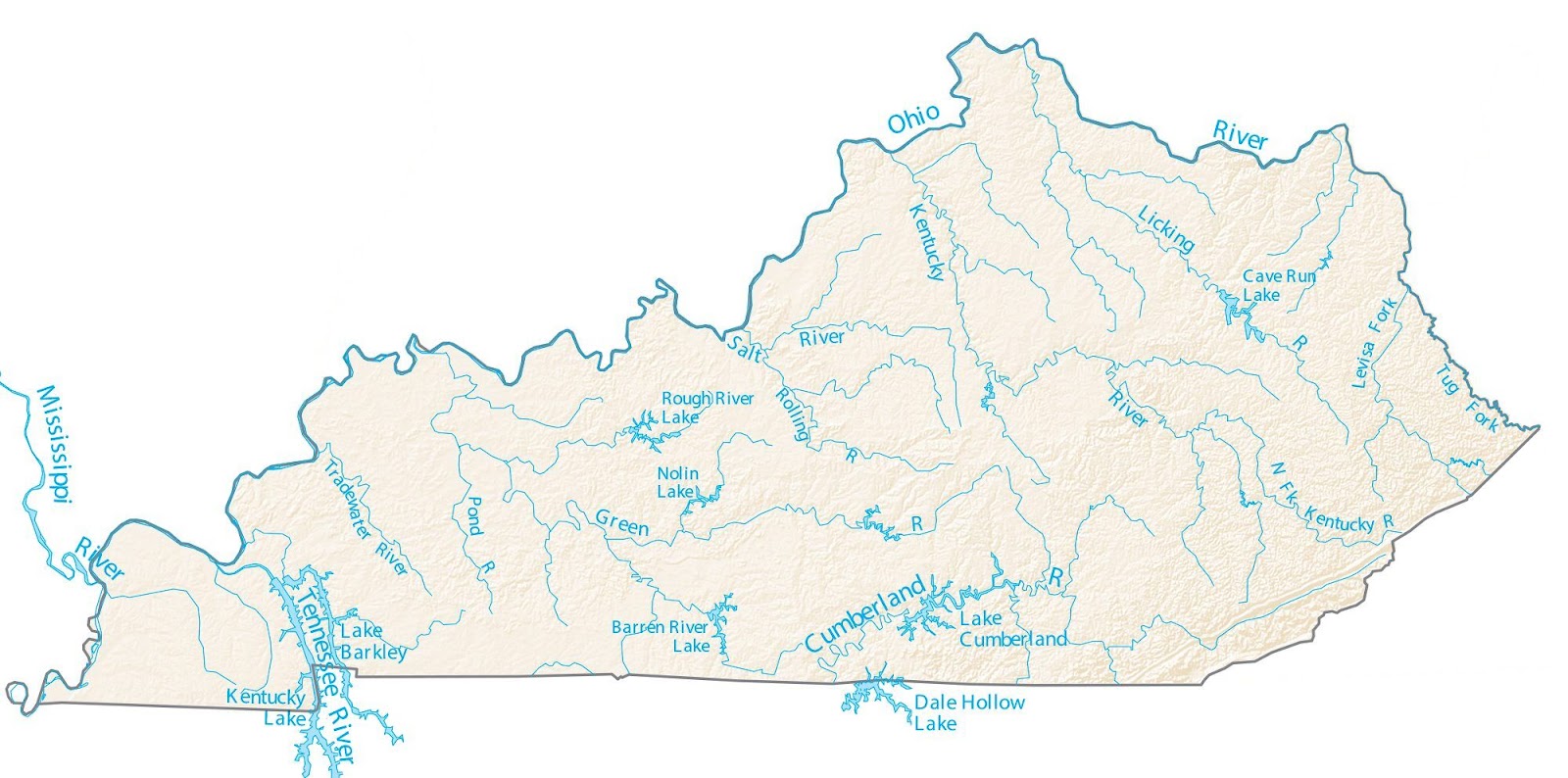
The state of Kentucky is known for its rolling hills, horse farms, and the famous Kentucky Derby. But the Bluegrass State is also home to a vast network of rivers that are essential to its ecosystem, economy, and culture. In this essay, we will explore the Kentucky Rivers Map and learn about every river that flows through this beautiful state.
Kentucky Rivers Map

Click Here to Download
The Kentucky Rivers Map showcases 7 major rivers that are over 100 miles in length, numerous tributaries, and a vast system of streams and creeks. The following is a detailed description of each river, their origin, and their impact on the state of Kentucky.
- Ohio River: The Ohio River is the longest river in Kentucky, and it serves as the northern border of the state. The river stretches for 981 miles and is the main artery of commerce for the region. The Ohio River is formed by the confluence of the Allegheny and Monongahela rivers in Pittsburgh, Pennsylvania. It then flows westward until it merges with the Mississippi River at Cairo, Illinois. The Ohio River is an important source of water for the residents of Kentucky, and it is also used for recreational purposes such as boating, fishing, and water sports.
- Cumberland River: The Cumberland River flows for 688 miles and is a major tributary of the Ohio River. The river originates in Harlan County, Kentucky, and flows through the Cumberland Falls State Resort Park, where it forms the famous Cumberland Falls. The Cumberland River is an important source of hydroelectric power and is also used for navigation, recreation, and as a water source for many communities.
- Green River: The Green River is 384 miles long and originates in Lincoln County, Kentucky. The river flows through Mammoth Cave National Park and is a popular destination for canoeing, kayaking, and fishing. The Green River is also an important source of water for many communities, and it is home to a diverse range of aquatic life.
- Kentucky River: The Kentucky River is 260 miles long and is a major tributary of the Ohio River. The river originates in Beattyville, Kentucky, and flows through the state capital, Frankfort. The Kentucky River is an important source of drinking water for many communities and is also used for recreation and transportation.
- Licking River: The Licking River is 320 miles long and originates in Magoffin County, Kentucky. The river flows through the cities of Covington and Newport, where it joins the Ohio River. The Licking River is an important source of water for many communities and is also used for recreation and as a habitat for a diverse range of aquatic life.
- Mississippi River: The Mississippi River forms the western border of Kentucky and is the second-longest river in the United States. The river flows for 2,320 miles from its source in Lake Itasca, Minnesota, to its mouth in the Gulf of Mexico. The Mississippi River is an important source of water for the entire region and is used for navigation, recreation, and as a source of hydroelectric power.
- Big Sandy River: The Big Sandy River is 135 miles long and is a tributary of the Ohio River. The river originates in Virginia and flows through the eastern part of Kentucky. The Big Sandy River is an important source of water for many communities, and it is also used for recreation and as a habitat for a variety of aquatic species.
In addition to these major rivers, Kentucky is also home to numerous tributaries, streams, and creeks. These smaller waterways are an important source of water for the local communities and are also used for recreation and as a habitat for a wide range of aquatic life. Some of the notable tributaries of the rivers in Kentucky include the Rockcastle River, the Elkhorn Creek, the Salt River, and the Red River. The Rockcastle River is a 54-mile tributary of the Kentucky River and is known for its clear water and beautiful scenery. The Elkhorn Creek is a 75-mile tributary of the Kentucky River and is a popular destination for fishing, kayaking, and tubing. The Salt River is a 150-mile tributary of the Ohio River and is used for recreation, as well as a source of water for many communities. The Red River is a 47-mile tributary of the Kentucky River and is known for its scenic beauty and clear water.
In conclusion, the Kentucky Rivers Map highlights the extensive network of waterways that flows through this beautiful state. Each river and tributary has its unique characteristics and importance to the region. The rivers of Kentucky are not only an essential part of the ecosystem, but they also have played a significant role in the state’s history, economy, and culture. As Kentuckians work to protect and restore their rivers, they are preserving a valuable resource that is crucial to the health and well-being of their communities and the natural world around them.


