Learn about Barbados with a Free Printable Labeled and Blank Barbados Map in PDF; it is an Island and a British Commonwealth nation. The largest city and capital is Its capital, and the largest city is Bridgetown. It’s a tiny country but full of natural beauty. Get to learn and know about it with the given maps. More can be seen in the printable world map.
Table of Contents
Blank Outline Map of Barbados
Barbados Map with States
Blank Map of Barbados
Labelled Map of Barbados
Printable Map of Barbados
About Barbados
Land in Barbados
Soils, drainage, and relief in Barbados
Barbados’ climate
Animal and plant life in Barbados
Languages and Ethnic groups in Barbados
Religion in Barbados
Settlement Patterns in Barbados
Demographic Trends in Barbados
Agriculture and fishing; Important industries in Barbados
Manufacturing and resources in Barbados
Finance and commerce in Barbados
Blank Outline Map of Barbados
Barbados’ population was predicted to be 287,375 people in mid-2020, accounting for 0% of the global population. Barbados is number 183 on the list of nations and dependent territories by population. The blank outline map of Barbados shows the country’s outer borderlines and serves as a guide for pupils to manually build an accurate map of the island. If the user is unsure how to begin sketching a map of Barbados, the student should use this blank outline Barbados Map.
Barbados Map with States
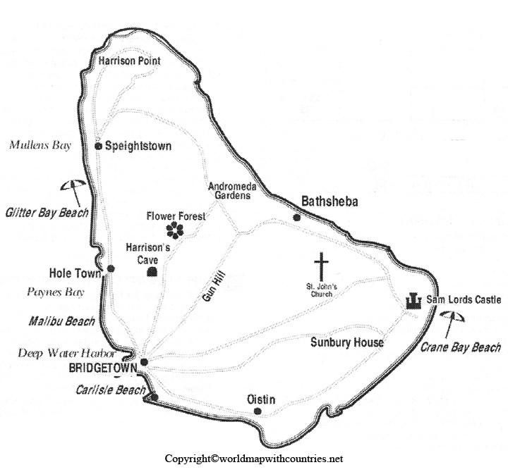
Barbados is the only country in the Caribbean to have been a colony of the British Empire for over 300 years, which is why it is affectionally called sometimes as little England. Of course, English is the official language but with a different but subtle Barbadian dialect known as Bajan. Located in the southwest part of the country is Bridgetown, the capital, with a little more than a third of the population. Here, we have provided you with the Barbados Map with state, and you can use it for any purpose of your choice.
Blank Map of Barbados
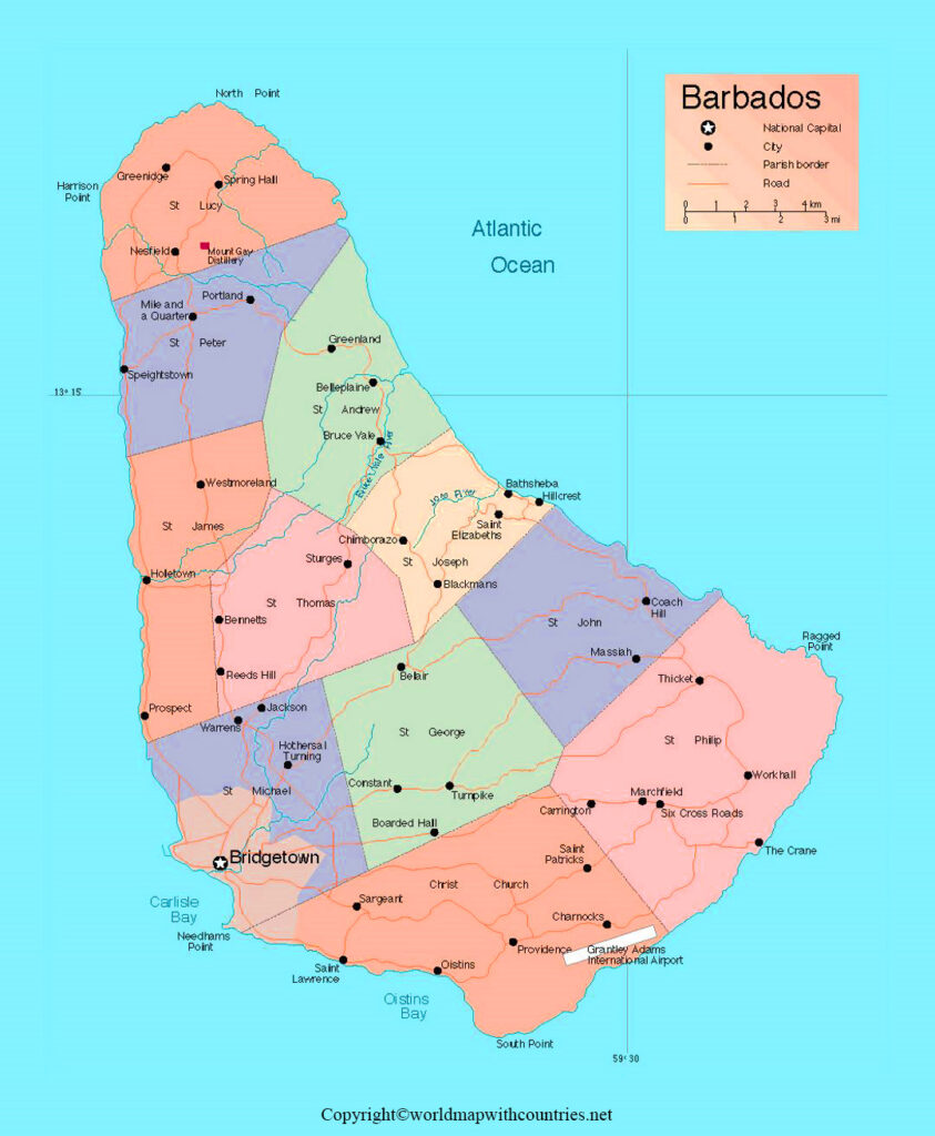
Barbados is located in the Atlantic Ocean, just east of Saint Vincent and The Grenadines in the Caribbean. It’s located 100 miles out of the Atlantic Ocean and a part of the Caribbean.
The total land area is about 430 square kilometers and has a coastline length of about 97 kilometers. The capital is Bridgetown, located in the southwest part of the island, and the country has eleven parishes. The blank Map of Barbados is provided here for educational and personal use.
Labelled Map of Barbados
In the labelled Map of Barbados, you will see that most of the country is plain and less mountainous and has less variety in plant and animal life. The highest point in Barbados is Mount Hillaby, with a rise of 1,102 feet. December to May is the dry season for the country, whereas the rest of the year is wet with rainfall.
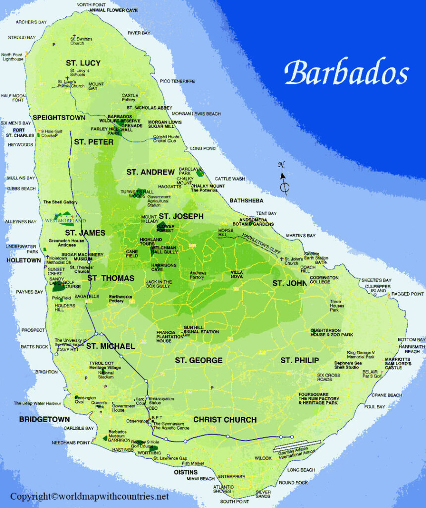
Printable Map of Barbados
They enjoy a lot of steel drum Clipsal music, carnival, and they have a harvest festival called Crop Over. They have six official on-site Embassies from other countries. Other countries such as Jamaica, Mexico, and Belgium host, many off-side Embassies in countries like Colombia, Denmark and France. Bruce Vale river, Joes River, Long Pond River, Constitution River, and Indian River are the major rivers of Barbados, which flow for 34km and rest there is no other drainage system in the country. View and download the printable Map of Barbados below:
About Barbados
Barbados is a Caribbean island republic located about 100 miles (160 kilometers) east of Saint Vincent and the Grenadines. The island is somewhat triangular, measuring 20 miles (32 kilometers) from northwest to southeast and 15 miles (25 kilometers) from east to west at its widest point. Bridgetown is the capital and largest city, as well as the primary harbor.
Barbados’ geographic location has significantly impacted the island’s history, culture, and economic life. Barbados is not part of the Lesser Antilles archipelago, yet it is frequently lumped together. The island has a distinct geologic formation than the mainland; it is less rugged and has fewer plant and animal species. Barbados has served as a vital link between western Europe (primarily Great Britain), eastern Caribbean countries, and sections of the South American mainland since the late 17th century, as the first Caribbean landfall from Europe and Africa. From the 17th century until 1966, when it gained independence, the island was a British dominion without interruption. Barbados’ culture is perhaps more British than any other Caribbean island because of its historical affiliation with Britain, yet parts of the majority population’s African culture have been significant. The nation has promoted Cultural nationalism as part of its nation-building process since its independence.
Land in Barbados
Barbados’ rocks are sedimentary formations that date 70 million years and include thick shales, clays, sands, and conglomerates. The chalky deposits above these rocks were topped with coral before the island rose to the surface. Except in the northeast physiographic region known as the Scotland District, which comprises about 15% of the island, where erosion has eroded the coral cover, a layer of coral up to 300 feet (90 meters) thick still covers the island. To prevent future decay, the government has devised a conservation plan.
Soils, drainage, and relief in Barbados
Mount Hillaby, Barbados’ highest point, rises to 1,102 feet (336 meters) in the island’s north-central region. The terrain descends to the sea in a series of terraces to the west. The ground drops rapidly east of Mount Hillaby to the Scotland District’s rocky upland. The mountains slope sharply to the large St. Georges Valley to the south, where the ground rises to 400 feet (120 meters) to form Christ Church Ridge between the valley and the sea. Coral reefs surround the majority of the island. In the late twentieth century, sewerage systems were developed to combat the hazard of fertilizer and untreated garbage runoff to the reefs.
There are few streams, springs, ponds, and no big rivers or lakes. Rainwater swiftly percolates through the underlying coralline limestone top, flowing into underground streams that serve as the primary source of domestic water. A desalination plant adds to the supply of fresh water.
The soils in Barbados are mostly residual. They’re clayey and high in phosphates and lime. Soil type varies with elevation; thin black soils can be found on the coastal plains, while more fertile yellow-brown or red soils can be found in the coral limestone’s upper reaches.
Barbados’ climate
Barbados has a typically pleasant climate. The temperature rarely rises beyond the mid-80s (about 30 degrees Celsius) or falls below the low 70s Fahrenheit (about 22 degrees Celsius). The dry season runs from early December to early May, followed by the wet season, which lasts the rest of the year. The average annual rainfall is roughly 60 inches (1,525 mm). However, rainfall varies, rising from the low-lying coastal sections to the high central district, despite the island’s tiny size. Barbados is on the southern edge of the Caribbean hurricane (tropical cyclone) zone, where hurricanes have wreaked havoc, most recently in 1780, 1831, 1898, and 1955.
Animal and plant life in Barbados
On Barbados, almost little of the ancient vegetation survives; the pale green of farmed sugarcane has become the landscape’s signature color. Poinciana, mahogany, frangipani, and cabbage palm are common tropical trees, while floral plants adorn parks and gardens. Monkeys, hares, and mongooses are among the few wild creatures considered pests by farmers. Doves, hummingbirds, sparrows, egrets, and yellow-breasted mergansers are some of the birds, while flying fish, sprats, green dolphins, kingfish, barracudas, mackerels, and parrotfish are some of the marine fauna.
Languages and Ethnic groups in Barbados
More than nine-tenths of the population is of African or mixed African-European ancestry. A small percentage of the population is of European (primarily British) ancestry, and even fewer are from the Indian subcontinent. Small clusters of Syrians, Lebanese, and Chinese have formed. International public officials, businesspeople, and retirees make up a substantial expatriate community, particularly from the United States and the United Kingdom. The official language is English, but they widely speak a dialect known as Bajan.
Religion in Barbados
The majority of people are Christians. The largest single religion is Anglicanism, which is the religious legacy of the British colonists who arrived in the 17th century. The Methodist and Moravian churches are two such denominations founded in the 18th century. However, during the nineteenth century, there has been a significant increase in religious variety. The Seventh-day Adventist church has a minority of adherents, whereas Pentecostal denominations have large congregations. Jehovah’s Witnesses, Roman Catholics, Bahais, Jews, Hindus, and Muslims are among the smaller groups.
Settlement Patterns in Barbados
Barbados has a high population density. Bridgetown and the surrounding area are home to more than a third of the population. Large landowners or businesses own the majority of the cropland. As a result, tenantries, which are clusters of wooden cottages known locally as chattel houses that are on the edges of big estates, are as prevalent as the local villages. The occupants usually own them, but they are built on rented land and can be readily moved to another area. They all have running water and power. Multistory structures modify the 19th-century town’s features in Bridgetown’s commercial and administrative center. Speightstown, Oistins, and Holetown are the major towns or communities outside of Bridgetown.
Demographic Trends in Barbados
Barbados had a rapid pace of population increase until the mid-20th century, causing overcrowding issues. The successful adoption of a statewide family-planning program, as well as steady emigration, first to Britain, then to other regions of the Caribbean and North America, slowed the rate of growth in the second half of the twentieth century and into the twenty-first. Death and infant mortality rates fell substantially, and life expectancy surpassed 70 years.
Barbados’ economy is open and market-oriented. The most important industries are services, manufacturing, and agriculture. Remittances from Barbadians living abroad provide a significant source of income. Barbados’ per capita income is relatively high.
Agriculture and fishing; Important industries in Barbados
About three-quarters of the area is arable, with sugarcane being the most common crop. Until the 1950s, sugar production dominated the economy, but it has since diminished in importance. Although big farm units continue to dominate agricultural production, the pattern of production has shifted owing to dropping sugar prices and government-sponsored agricultural diversification, and limited land settlement schemes. As a result, food production (vegetables, fruits, and cattle) has increased significantly, primarily for local use. Also farmed is high-quality sea island cotton. Tropical flower and foliage cultivation has also proven profitable. Fishing has traditionally been an essential element of the island’s economy, and the government has helped to modernize the business.
Manufacturing and resources in Barbados
Barbados has limited natural resources, from modest crude oil and natural gas deposits that provide around one-third of the island’s energy needs. The most notable element of continued economic activity has been the sustained exploitation of the climate and beaches for their tourist potential. One of the island’s resources maybe its large population, which provides a convenient source of labor. Remittances from the population working abroad have made significant contributions to the economy.
The mining industry is limited to oil and natural gas production, with some clay, limestone, and sand quarrying. Manufacturing was one of the key growing areas of the economy, aided by government incentives; however, beginning in the late twentieth century, this trend was reversed due to globalization and trade liberalization, which boosted competition from cheaper imports.
Finance and commerce in Barbados
Barbados’ banking system comprises the central bank (the Central Bank of Barbados, founded in 1972), commercial banks, and different development-oriented financial institutions, such as credit unions. The majority of commercial banks are regional and local branches of international banks. The Barbados dollar is the official currency.
Since 1987, minor stock exchange has traded shares of locally and regionally owned businesses. It now only conducts business online. Links with similar deals in Trinidad & Tobago and Jamaica promote cross-border commerce. The offshore financial sector increased in the late twentieth and early twenty-first centuries, and it was heavily regulated. Food and beverages, chemicals, and electrical components are among the top exports. Capital goods, food and beverages, mineral fuels, and chemicals are significant imports. The United States, Trinidad and Tobago, China, the United Kingdom, Japan, and other Caribbean Community and Common Market countries are Barbados’ key trading partners.


