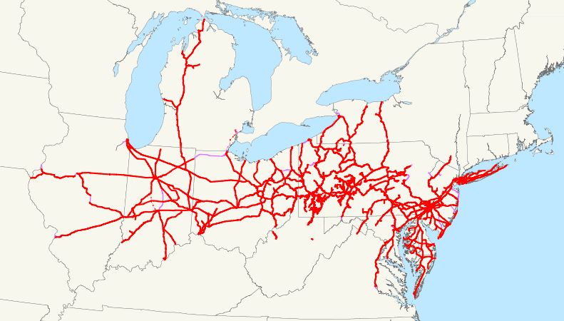
The Pennsylvania Railroad Map is a valuable resource for anyone interested in the history of transportation in the United States. It provides a glimpse into the extensive network of railways that once crisscrossed the state of Pennsylvania, connecting major cities and towns, carrying passengers and goods across the country.
Pennsylvania Railroad Map

Click Here to Download
Pennsylvania was home to some of the most important railroads in American history, including the Pennsylvania Railroad (PRR), the Reading Railroad, and the Lehigh Valley Railroad. Each of these railroads played a significant role in shaping the development of the state and the nation.
The Pennsylvania Railroad was one of the largest and most powerful railroad companies in the United States. It was founded in 1846 and operated for over a century, until it merged with the New York Central Railroad in 1968. At its peak, the PRR had over 10,000 miles of track and employed over 250,000 people. Its main line ran from Philadelphia to Pittsburgh, and it had branches that extended to New York City, Washington D.C., and Chicago.
The Reading Railroad was another major railroad company in Pennsylvania. It was founded in 1833 and operated until it was merged into the Consolidated Rail Corporation in 1976. The Reading Railroad was known for its coal transportation, as it was located in the heart of Pennsylvania’s coal region. It also provided passenger service to major cities like Philadelphia, New York City, and Baltimore.
The Lehigh Valley Railroad was founded in 1846 and operated until it was merged with Conrail in 1976. The railroad’s main line ran from New York City to Buffalo, and it served the coal and iron industries in the Lehigh Valley region of Pennsylvania. The Lehigh Valley Railroad also provided passenger service to major cities like New York City, Philadelphia, and Buffalo.
In addition to these major railroad companies, there were many smaller railroads that operated in Pennsylvania. These included the Erie Lackawanna Railroad, the Pittsburgh and West Virginia Railway, the Baltimore and Ohio Railroad, and the Delaware and Hudson Railway, among others.
Each of these railroads played a unique role in the development of Pennsylvania and the United States. For example, the Pennsylvania Railroad was instrumental in the transportation of goods during World War II, as it carried troops and supplies across the country. The Reading Railroad was known for its innovative locomotives and rolling stock, and it was one of the first railroads to use diesel-electric locomotives. The Lehigh Valley Railroad was a major player in the transportation of anthracite coal, which was an important energy source during the early 20th century.
The Pennsylvania Railroad Map provides a detailed view of the railway system that once existed in Pennsylvania. It shows the major cities and towns that were connected by rail, as well as the various branches and lines that extended across the state. By studying the map, it is possible to see how the railroads shaped the development of Pennsylvania and the surrounding regions.
Today, many of the railroads that once operated in Pennsylvania are no longer in existence. However, their legacy lives on through the many historic sites and landmarks that dot the state. These include the Horseshoe Curve, a famous railroad engineering feat that is now a national historic landmark, and the Railroad Museum of Pennsylvania, which houses a collection of historic locomotives and rolling stock.
In conclusion, the Pennsylvania Railroad Map is a valuable tool for understanding the history of transportation in Pennsylvania and the United States. It provides a detailed view of the extensive railway network that once crisscrossed the state, connecting major cities and towns and carrying passengers and goods across the country. By studying the map and learning about the various railroad companies that operated in Pennsylvania, we can gain a deeper appreciation for the role that transportation has played in shaping the state’s history and identity.


