Large labeled Map of Eastern Europe: Europe is one of the seven continents in the World. Europe is also home to several big cities that account for a good number of GDP despite not having many populations.
Table of Contents
Large Labeled Map of Eastern Europe
Eastern Europe Countries Map
Countries of Eastern Europe
Large Labeled Map of Eastern Europe with Major Cities
Large Labeled Map of Eastern Europe with Capitals
Blank Map of Eastern Europe
Physical Large Labeled Map of Eastern Europe
World Map of Eastern Europe
Large Labeled Map of Eastern Europe
This political map is helpful to both: Political science students and Geography students. So, the person reading this, if you need this map, you can download them free of charge.

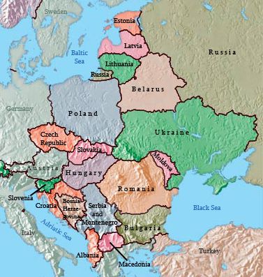
Eastern Europe Countries Map

Eastern Europe means the Eastern part of the Europe countries. It covers all the nations that lie in the eastern part of Europe. It does not use the appropriate and exact area it covers, but it is the rough idea of dividing and recognizing the continent in the East, West, North and South directions. You can download the Eastern Europe countries map free of charge from here and also the printable map of the world.
Countries of Eastern Europe
- Hungary: During the Communist period, Hungary enjoyed a higher standard of living than its neighbors. It was likely the marked contrast in daily life between the Communist period and the post-Communist period that influenced the outcome of the 1994 elections, which gave the Hungarian Socialist Party, led by former Communists, an absolute majority in parliament. Many were concerned that Hungary was signaling a wish to return to the past. Still, instead, all three main political parties joined together to work toward the common goals of continued liberalization of the economy, closer ties with the West, and full EU membership.
- The Czech Republic and the Slovak Republic (Slovakia): Each country in Eastern Europe has a different story regarding its path from communism to independence. Countries like the Czech Republic and Hungary were more prepared and better equipped to meet the challenges and were early qualifiers for entry into the EU. Historically, the region occupied by the modern Czech Republic was known as Bohemia and Moravia. The Czech Republic and Slovakia were, until recently, part of the same country: Czechoslovakia, which was created in 1918 from part of the Austro-Hungarian Empire after World War II ended. On January 1, 1993, they became two newly independent nations. Slovakia is known officially as the Slovak Republic.
- The Baltic Republics: The small Baltic states of Latvia, Estonia and Lithuania transitioned away from their old Soviet connections. After independence, they quickly looked toward Western Europe for trade and development. Most Eastern European countries followed this pattern. Latvia, Estonia, and Lithuania received their independence from the Soviet Union in 1991. Russia withdrew its troops from the region in 1994. The North Atlantic Treaty Organization (NATO) and the EU welcomed them as members in 2004. They have transitioned to market economies with democratic governments. The people of Latvia, Estonia, and Lithuania rapidly expanded their economic conditions after independence but have been hard hit by the downturn in the global marketplace in 2008.
- Poland: Poland has a long-standing history of working to oppose the Communist domination of its country. The Solidarity movement in Poland started as an independent trade union in the 1980s but became a lightning rod for political change in Poland. The Communist Party dominated politics and suppressed any movement to organize labor or the people against the government. The strength of Solidarity became evident in the 1990 election when Solidarity candidate Lech Wałęsa won Poland’s presidential election. Solidarity’s victory signified the collapse of the power of the Soviet Union and Communism in Eastern Europe. The country has emerged with a democratic government and a thriving capitalist economy.
- Moldova: A variety of cultural and social forces provided different levels of civility in the transitions of Eastern Europe. The poor, agricultural economy of the small, landlocked country of Moldova provides few opportunities or advantages to grow its economy and provide a stronger future for its people. As a result, young people earning an education or technical skills immigrate to other countries for opportunities or employment.
- Belarus: In 1991, independence came to the former Soviet Republic of Belarus, but Belarus took a different path from most of the other Eastern bloc countries. Belarus did not distance itself from its Russian connection. Belarus has consequently experienced authoritarian governments well into the twenty-first century. In this case, Russia and Belarus created a more robust relationship by signing agreements to increase economic integration. Difficulties have hindered the implementation of many of these policies. Belarus’s government has also been slow to move toward democratic reforms. The president has taken on more extraordinary authoritarian powers. Some of the personal freedoms that have been granted in other European countries—freedom of the press, free speech, and the right to peacefully assemble—are still restricted in Belarus. As of 2010, Belarus, Ukraine, and Moldova have not been admitted into the EU. Belarus has indicated that it might join with the Russian Republic and has not even applied for entry into the EU.
- Ukraine: With the most significant physical area in Europe, Ukraine is slightly larger than France. Its population in 2010 was approximately forty-six million, and 77 percent of the population is ethnically Ukrainian and 17 percent in Russian. Most of the population lives in the industrial regions of the southeast or eastern parts of the country. Though the official language is Ukrainian, many Ukrainians still speak Russian. As is the case with neighboring states, the Eastern Orthodox Church dominates the religious and cultural reflections of the arts, literature, and architecture. Christian themes are often reflected in the paintings, books and performances. Though Ukraine has transitioned from a Soviet republic to a fully independent country, divisive centrifugal forces have made Ukraine’s path to free elections and democratically elected leaders difficult. The country has held political polls, but they have been challenged or tainted with corruption and accusations of fraud. Today, the country has a democratically elected government and is working toward improving its economy and creating stability for its people.
- Romania: Several countries in Eastern Europe have fully transitioned from Communist dictatorships to modern, integrated economies. Romania is one of those countries. Romania encompasses an area equivalent to the US state of Minnesota. Its population of 21.5 million people includes two million who live in Bucharest, the capital and largest city of the country. The Carpathian Mountains circle Romania, with the Transylvanian Alps to the south. The Danube River runs across the region and creates a natural border with Bulgaria and Serbia before flowing into the Black Sea. The Romanian forests are some of the largest in Europe, with about half (13 per cent of the country) set aside from logging and placed in watershed conservation programs. The integrity of the ecosystems in the Romanian forests provides diverse habitats for plants and animals. Romania claims to have the most European brown bears and about 40 per cent of all European wolves living within its borders.
- Albania: The southern Adriatic is home to the small country of Albania. The rugged mountainous country of Albania has a Muslim majority. Poverty, unemployment, and a lack of opportunities to gain wealth have plagued the country. Albania has even received Communist support from China. As a result of the war in Kosovo, Albania suffered a significant setback in its progress toward an improved standard of living and integration with the rest of Europe. When there is stability, Albania can progress toward becoming more integrated with the European economy and raise its standard of living for its people. There has been Parliamentary democracy since the Communist era, and foreign investments have aided in developing updated transportation and power grids.
- Bulgaria: Located at the crossroads of the continents, Bulgaria has a central trans-European corridor running through its territory that connects to Asia. The country is home to diverse landscapes, including the sunny Black Sea coast and the higher elevations of the Balkan Mountains, which reach a height of 9,596 feet. The Danube River flows across the border with Bulgaria to the Black Sea. About one-third of the country consists of plains, providing extensive agricultural activity. We can also find Ore and minerals in Albania, which has allowed the government to gain wealth.
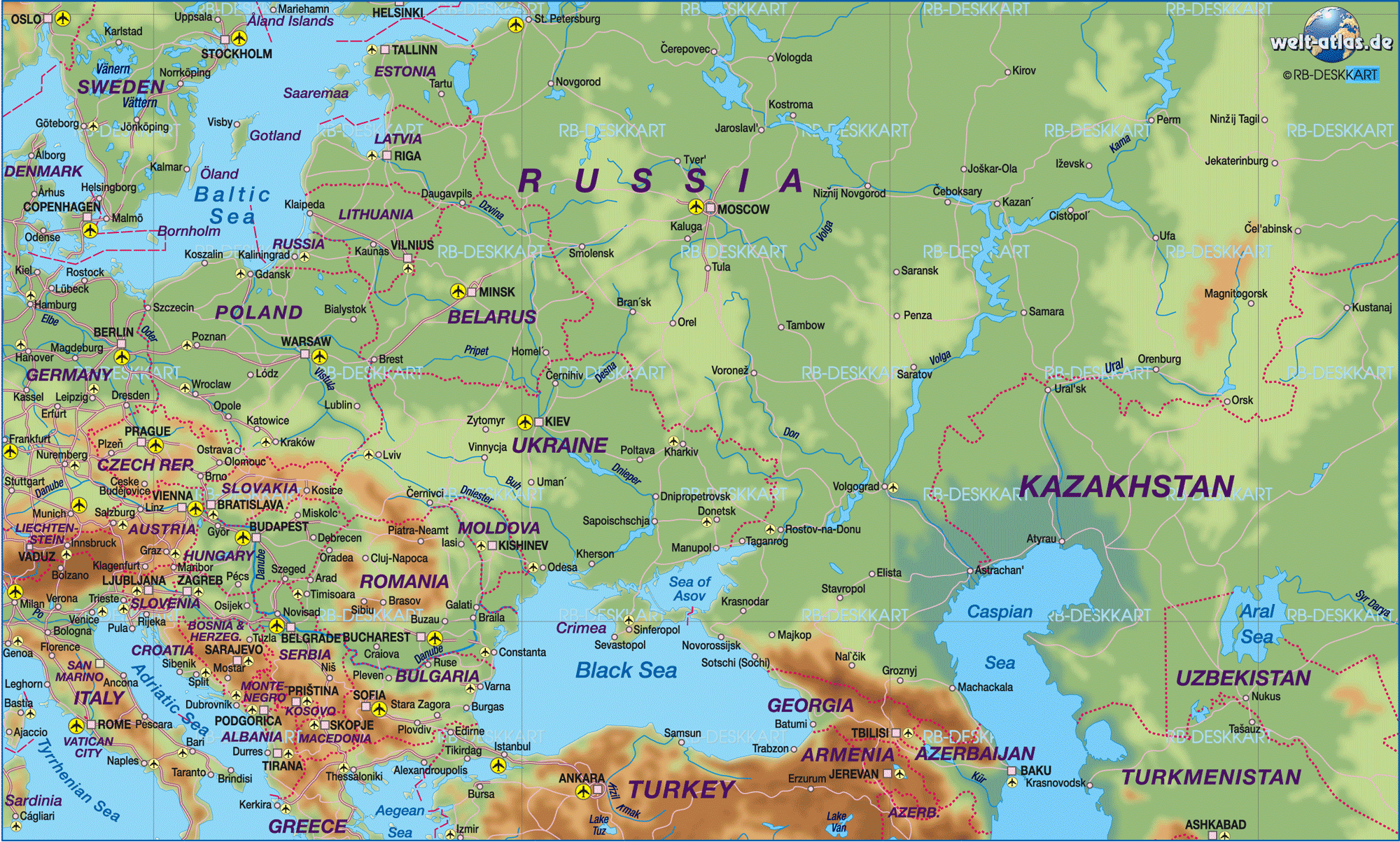
Large Labeled Map of Eastern Europe with Major Cities

Every country has its significant cities known to the world and is famous across the globe for any particular reason. The Eastern Europe countries have some big cities known to the world. If your teacher asks you to note down the big Eastern Europe countries, then this map we are providing may help you. You can locate all the big cities. If you want to download this map, you can download the large labeled Map of Eastern Europe with major cities.
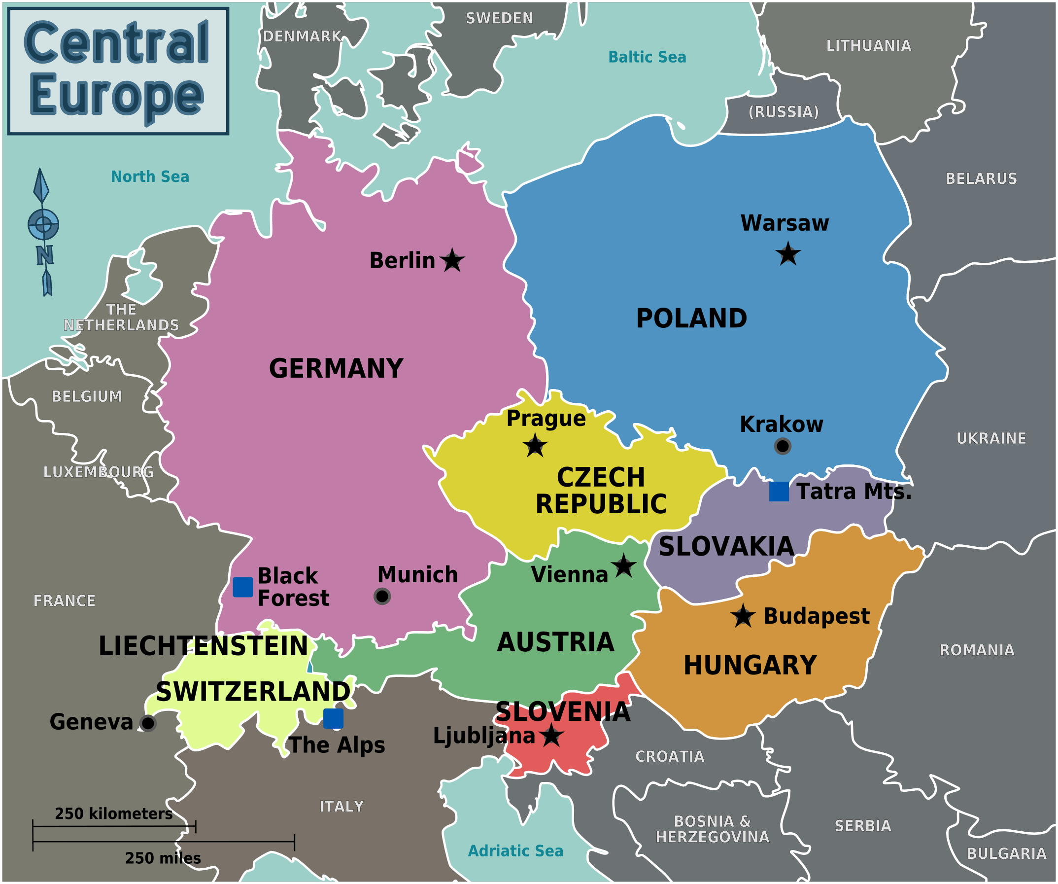
Large Labeled Map of Eastern Europe with Capitals
Every country has its capital which is one of the most important cities in that country. Every money has its unique place. If it’s the country’s capital, then it has the international value because all the work and relations that a country has to maintain internationally go through its capital. In diplomatic issues, instead of writing the country’s name, the capital name is mentioned.

Blank Map of Eastern Europe
The Blank map of the Eastern part of Europe has been provided to you free of charge. You can download the map from here. If you are a geography student, then this map may be helpful to you: First of all, it saves your time, you do not have to go anywhere in search of the map and secondly, it is economical.

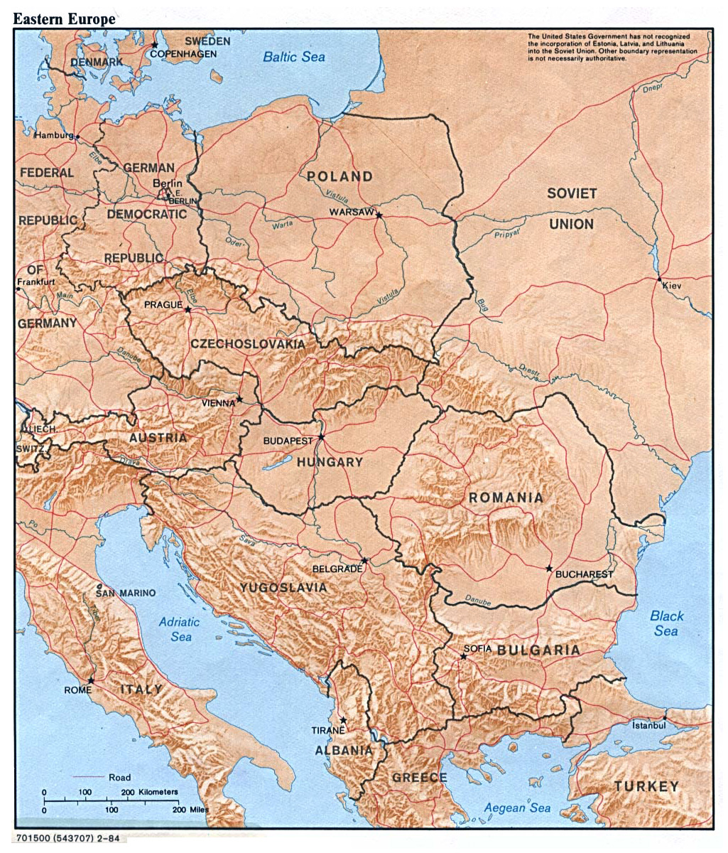
Physical Large Labeled Map of Eastern Europe
The Physical large labeled map of Eastern Europe has been provided to you free of charge. You can download the map from here.
Europe is a complex geographic region when examining its human and physical characteristics. The largest city in Europe is Istanbul, Turkey, with approximately 14 million inhabitants, followed by Moscow, Russia, with 12 million people, and London, United Kingdom, with about 8.5 million people. Other cities of significant size are St. Petersburg, Russia; Berlin, Germany; Madrid, Spain; Rome, Italy; Kyiv, Ukraine; and Paris, France. Given that Europe is one prominent peninsula, there are numerous miles of coastline, as well as several significant rivers. With this geography available, you will learn that many European countries exist on waterways and coastlines.

The Thames River in London, the Seine in Paris, the Havel and the Spree in Berlin, St. Petersburg (Russia) on the Gulf of Finland, and Istanbul located between Marmara and the Black Sea. Water access provides coastal plains, which are usually fertile for agriculture, the option to transport goods, people, and ideas.
The subcontinent of Europe is physically diverse with mountains, rivers, valleys, and lakes, especially considering its smaller size. The most extensive mountain range is the Alps, located in France, Italy, Switzerland, and Germany. The tallest mountains in Europe are Mount Elbrus in Russia at 18,510 feet and Mount Ararat in Turkey at 16,854 feet, followed closely by Mont Blanc in the Alps at 15,781. Well, known European valleys are the Loire and Rhone valleys in France and the Danube river valleys in Germany, Austria, Slovakia, and Hungary. The Danube is the longest river in Europe. In addition to the previous mention of the Thames, Seine, Havel, and Spree rivers, other sizable rivers in Europe are the Elbe in the Czech Republic and Germany, the Loire in France, and the Rhine, which moves through nine countries in western Europe. The two largest lakes are Lake Ladoga in Russia and Vanern Lake in Sweden.
World Map of Eastern Europe

We have provided the World map of Eastern Europe here, and you can download them free of charge.


1 Comment