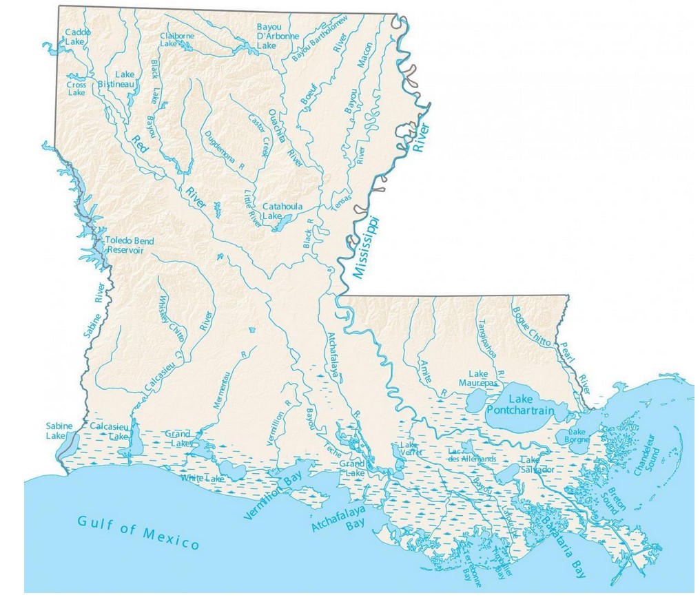
Louisiana is a state in the southern United States, known for its unique culture, spicy cuisine, and extensive waterways. The Louisiana Rivers Map features a wide range of waterways, including large rivers, bayous, and streams that span the state. In this essay, we will provide detailed information about each of the major rivers in Louisiana.
Louisiana Rivers Map

Click Here to Download
- Mississippi River: The Mississippi River is the most prominent river in Louisiana, flowing for 600 miles along the state’s eastern border. The Mississippi is the second-longest river in the United States, and its tributaries drain almost 40% of the continental United States. The river has played a significant role in Louisiana’s history, serving as a major trade route and influencing the state’s culture.
- Red River: The Red River runs for 235 miles along the northwestern boundary of Louisiana. The river originates in Texas and flows through Louisiana and Arkansas before joining the Mississippi River. The Red River has a significant impact on Louisiana’s agriculture, providing irrigation for crops and serving as a critical source of drinking water for many communities.
- Ouachita River: The Ouachita River is a 605-mile-long river that runs through Arkansas and Louisiana. The river’s name comes from the Native American word for “good hunting grounds,” and it has played a vital role in Louisiana’s history, serving as a transportation route for timber and other goods.
- Atchafalaya River: The Atchafalaya River is a 137-mile-long distributary of the Mississippi River, located in southern Louisiana. The river flows through the Atchafalaya Basin, one of the largest wetland areas in the United States. The Atchafalaya River serves as a critical habitat for many species of wildlife and supports Louisiana’s fishing and seafood industries.
- Sabine River: The Sabine River forms part of the border between Louisiana and Texas, running for 555 miles through both states. The river flows into Sabine Lake, a large saltwater estuary that provides habitat for numerous species of fish and wildlife. The Sabine River has a significant impact on Louisiana’s economy, serving as a transportation route for oil and gas production.
- Calcasieu River: The Calcasieu River runs for 200 miles through southwestern Louisiana, emptying into the Gulf of Mexico. The river is a vital transportation route for shipping and supports Louisiana’s fishing industry. The Calcasieu River also provides numerous recreational opportunities, including boating, fishing, and birdwatching.
- Pearl River: The Pearl River forms part of the border between Louisiana and Mississippi, running for 490 miles through both states. The river flows into Lake Borgne, a large brackish water body that supports many species of fish and wildlife. The Pearl River is an important source of drinking water for many Louisiana communities.
- Mermentau River: The Mermentau River is a 72-mile-long river located in southwestern Louisiana. The river flows into the Gulf of Mexico, providing habitat for numerous species of fish and wildlife. The Mermentau River is an important source of freshwater for the region’s agriculture and industry.
- Tensas River: The Tensas River is a 260-mile-long river located in northeastern Louisiana. The river flows into the Black River, which empties into the Red River. The Tensas River has a significant impact on Louisiana’s environment, providing habitat for numerous species of fish, birds, and other wildlife.
- Amite River: The Amite River is a 117-mile-long river located in southeastern Louisiana. The river flows into Lake Maurepas, a large freshwater lake that supports many species of fish and wildlife. The Amite River serves as a popular recreational destination, providing opportunities for fishing, boating, and other water-based activities.
- Bayou Lafourche: Bayou Lafourche is a 106-mile-long bayou that originates in central Louisiana and flows southward, parallel to the Mississippi River. The bayou serves as a source of drinking water for more than 300,000 people in Louisiana and is an important transportation route for the state’s sugar cane industry.
- Bayou Teche: Bayou Teche is a 125-mile-long bayou that runs through central and south-central Louisiana. The bayou is known for its scenic beauty, and it has been designated as a National Water Trail. Bayou Teche is an important cultural and historical landmark, having played a significant role in the state’s Cajun and Creole cultures.
- Bayou Vermilion: Bayou Vermilion is a 70-mile-long bayou located in southwestern Louisiana. The bayou flows into Vermilion Bay, an estuary that provides habitat for many species of fish and wildlife. Bayou Vermilion is also a popular recreational destination, offering opportunities for fishing, boating, and kayaking.
- Bayou Bartholomew: Bayou Bartholomew is a 359-mile-long bayou that runs through Arkansas and Louisiana, making it the longest bayou in the world. The bayou provides habitat for many species of fish and wildlife, and it is a popular destination for hunting and fishing.
- Bayou Macon: Bayou Macon is a 129-mile-long bayou that runs through northeastern Louisiana and southeastern Arkansas. The bayou serves as an important transportation route for the region’s timber and agriculture industries, and it provides habitat for many species of fish and wildlife.
In conclusion, Louisiana is home to a diverse range of waterways, including large rivers, bayous, and streams. These waterways provide numerous ecological, economic, and recreational benefits to the state and its residents. Understanding the Louisiana Rivers Map and the detailed information about each river can help us appreciate and better manage these valuable resources.


